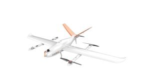
CHCNAV VTOL P330 PRO
The P330 Pro is a high-performance vertical takeoff and landing (VTOL) fixed-wing unmanned aircraft system (UAS), specially designed for aerial surveying and mapping applications.

CHCNAV VTOL P330 PRO
With its concept of high accuracy, long endurance and multiple payloads, it meets the requirements of mapping and aerial surveying professionals for many different applications. The P330 Pro features a 100 Hz differential module, which allows aerial mapping operations at the centimeter level, and a flight endurance with payload reaching more than 150 minutes.
Processing Features
to achive your goals

User Friendly Software

High Precision POS

Multiple Payloads
Industry Applications
Detail Parameters
more detail about CHCNAV VTOL P330 Pro Detail Specifications

Fuselage Length
1.21 meter
Wingspan
2.53 meter
Maximum Take-off Weight
14 Kg
Maximum Payloads
2 Kg
Engine
Full Electric
Box Dimension
1.25m*0.45m*0.45m
Maximum Endurance
150 mins
Maximum Range
150 Km
Cruising Speed
21 m/s
ADS-B
Support
Take-off/Landing Mode
Auto-VTOL
Maximum Altitude
6000 meters
Working Temperature
-20℃~50℃
Hor. Positioning Accuracy
1 cm+1 ppm
Ver. Positioning Accuracy
2 cm+1 ppm
Data Communication Distance
Up to 15 Km
Ver. Positioning Accuracy
2 cm+1 ppm
RTK Accuracy
H: 2 cm+1 ppm
V: 2 cm+1 ppm

